When you live or build in Los Angeles, the ground never truly stays still. Between the micro-quakes that roll underfoot and the sudden downpours that soak our hillsides, the land moves—sometimes just enough to throw an entire project off track. That’s why calling a construction surveyor after heavy rain or a small tremor isn’t overreacting. It’s smart protection for your investment and your safety.
The Hidden Shifts You Don’t See
A tiny earthquake may not make headlines, but it can make your retaining wall lean a fraction of an inch. Add days of heavy rain that saturate the soil, and that inch becomes a bigger problem. On hillside lots in Los Feliz, Pacific Palisades, or Mount Washington, gravity does slow but steady work. Water seeps in, soil expands, and slopes creep downhill.
Those small movements can knock survey stakes out of alignment or change elevation points that guide construction. When that happens, concrete foundations, decks, and driveways can end up sitting just a few inches off design grade. It may not sound like much, but in Los Angeles—where hillside zoning rules and drainage codes are strict—those inches matter.
That’s where a construction surveyor steps in. Their job is to make sure what you’re building still matches the approved plans, even after the earth beneath you shifts a little.
What a Construction Surveyor Really Does
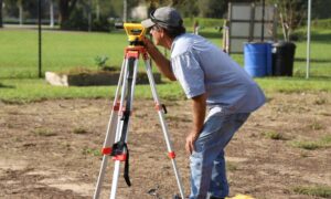
Many people think surveyors only show up at the start of a project to mark property lines. But construction surveying goes far beyond that. It’s the process of staking, measuring, and confirming that every element of your build—foundation, retaining wall, driveway, or drainage system—is in the right place and at the correct elevation.
After a storm or tremor, a construction surveyor re-checks the “control points” that form the backbone of your site layout. These points are like the GPS coordinates of your project. If one moves because the soil settled or a stake washed out, the rest of your measurements could be wrong.
Surveyors use advanced tools like total stations, GPS receivers, and digital levels to re-measure those coordinates down to millimeters. Then they compare the new data with your original plans. If they find even minor discrepancies, they reset the stakes so your crew can build accurately again.
This re-staking process keeps your contractor’s work aligned with the approved grading plan, protecting both your structure and your permit compliance.
When to Worry About Your Site
Los Angeles builders are used to unpredictable weather and the occasional shake, but not everyone knows when to bring in help. If you’re seeing these signs after recent rain or tremors, it’s time to call a construction surveyor:
- Cracks forming in concrete or retaining walls.
- Driveway or patio surfaces beginning to tilt.
- Fence lines that no longer look straight.
- Drainage water flowing differently than before.
- Wooden stakes or nails marking your foundation that look loose or out of place.
Even if everything appears fine, a short site check by a surveyor can save you thousands later. They can catch subtle elevation shifts before concrete is poured or before framing begins.
The Hillside Problem No One Talks About
Flat-lot construction is forgiving. The hillside building isn’t.
In neighborhoods like Studio City, Silver Lake, and Brentwood, homes cling to steep terrain supported by retaining walls, caissons, and deep foundations. These systems rely on precise elevations and exact spacing. When nature interferes, your whole structural plan can change.
Heavy rainfall increases the pressure behind retaining walls and softens the soil they anchor into. Then, when a micro-quake hits, that saturated ground moves just enough to shift those anchor points. It’s the perfect recipe for slope creep—slow, downward movement that might go unnoticed until cracks appear months later.
A construction surveyor helps catch that early. By re-measuring key elevations and slope angles, they can confirm if the site is still safe to continue building—or if it needs stabilization before construction resumes.
Why Small Quakes Still Matter
It’s easy to dismiss a 2.5-magnitude quake as harmless. But consider that most hillside projects rest on engineered fill—soil that was compacted and built up over time. Even a small vibration can loosen that fill or change its density slightly. Over time, those changes accumulate.
When a construction surveyor returns after these events, they’re not just checking numbers on a plan. They’re verifying the physical reality: Are the control points still valid? Has any settling occurred that changes elevation? Is the grade still draining water the right way?
That information helps the builder avoid uneven slabs, misaligned framing, or drainage failures that lead to water damage later on.
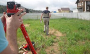
Technology Makes It Faster and Safer

Modern surveying tools make re-checks faster than ever. Many LA firms now use drone surveying and LiDAR scanning to map hillside terrain after storms. These tools capture detailed 3D models of your property in minutes, showing exactly where soil shifted or slopes changed.
The construction surveyor then overlays those scans on your design plans to detect even the slightest deviation. It’s precise, visual, and incredibly effective for large or hard-to-access lots.
Using this technology also helps speed up permit inspections. When you can show that your project’s elevations still match the approved grading plan, you build trust with city inspectors and lenders.
Staying Ahead of Problems
You don’t have to wait for damage to appear. Smart builders schedule follow-up surveying at key milestones:
- After major rain events.
- After any seismic activity, even mild.
- Before pouring concrete or installing structural supports.
- After excavation or backfill on steep slopes.
This habit keeps construction aligned and prevents expensive corrections later. It also gives your project a professional record of accuracy—something lenders, engineers, and future buyers appreciate.
A Simple Rule for Hillside Projects
In Los Angeles, the ground will move. The question is whether you’ll notice before it costs you.
By calling a construction surveyor after tremors or storms, you’re not just checking measurements. You’re confirming that your foundation, drainage, and slope grading remain safe and code-compliant.
It’s a small step that protects your investment, your neighbors, and your peace of mind. The next time the news mentions a local quake or a “once-in-a-decade” rainstorm, take it as a reminder: hillsides shift quietly, but the consequences can be loud and costly.
Before you build—or rebuild—make sure your site hasn’t changed beneath you.