Los Angeles homeowners are paying close attention to elevation surveys right now, and for good reason. New local flood-zone updates are rolling out, and many people are finding out their home may sit closer to risk than they once thought. With recent storms, hillside shifts, and fresh reports about land movement in places like Rancho Palos Verdes, more residents want to know exactly how high—or how low—their property stands. The good news is that getting the right data early protects your home, your insurance costs, and even your long-term plans.
These updates matter because they change how lenders, insurers, and even the city look at your property. A small change in elevation can affect your flood-risk rating, and that can raise your insurance premiums or require extra documentation. Many homeowners discover this only when refinancing, selling, or renewing their policy. Because of that, people across LA—especially those in hillside neighborhoods—are asking surveyors for help before surprises hit.
Why Flood-Zone Updates Matter Right Now
Flood-zone maps don’t change often, but when they do, they can affect thousands of homes overnight. This year, new local updates hit several LA communities, especially near creeks, storm channels, and older neighborhoods built close to slopes. Homeowners in these areas receive notes from their insurance companies or see new labels when checking FEMA’s online maps.
Those small redrawn lines make a big difference. If your home now sits in a higher-risk flood zone, your lender may request a new elevation certificate. If your home moves out of risk, you might qualify for lower premiums—but you still need proof. And if you’re planning to build or remodel, the city may stop your permit until you show accurate elevation data.
That’s when an updated elevation survey becomes essential. It gives a clear picture of your property’s height relative to known flood levels. With the weather becoming more unpredictable every year, the city wants to see accurate, current numbers—not estimates based on old maps.
What’s Happening in LA’s Hillside Areas
It isn’t just floods worrying homeowners. LA has another challenge happening at the same time: land movement. Recent updates in Rancho Palos Verdes reported that land movement has “slowed,” but it hasn’t stopped. The ground still shifts in some parts of the peninsula, and even slow movement can change your property’s elevation over time.
When the land shifts, your old survey becomes outdated. Even a small elevation change can affect drainage, foundation stability, and how water flows across your lot. Homes on slopes depend on accurate measurements more than flat neighborhoods do. If you live in a hillside area—Pacific Palisades, Malibu, Mount Washington, or Palos Verdes—you feel every storm season more than the rest of the city.
So when LA updates its flood and hazard maps at the same time hillside areas show signs of movement, homeowners want clarity. They want to know if their home stands higher or lower than before. They want to understand whether the last heavy rain changed anything important. And they want answers they can trust—not guesses.
That’s exactly what elevation surveys provide.
How Elevation Surveys Help Protect Your Home
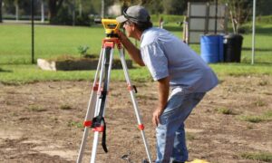
An elevation survey gives a detailed look at how high your house sits compared to surrounding ground and official flood levels. Surveyors measure the lowest parts of your home, the grade near your walls, and how water would likely move during strong rain. When your lot sits on a slope, those numbers are even more important, since water naturally finds the lowest point.
This information protects you in several ways:
You avoid surprise insurance hikes. Insurers base premiums on risk. If your elevation is higher than the flood map suggests, a proper survey can prove it and lower your costs.
You stay ahead of city rules before building or remodeling. LA requires accurate elevation data for many projects, especially ADUs, hillside rebuilds, and drainage improvements. Getting the survey early keeps your plans moving.
You catch ground shifts early. If your elevation changed since your last survey, it may signal slow land movement. That’s something you want to know before cracks or drainage issues appear.
You protect your home’s value. Buyers prefer homes with updated records. When they see an up-to-date elevation survey, they feel more confident about the property.
This is why more homeowners see elevation surveys as a smart move, not just paperwork.
What Homeowners Are Noticing Right Now
Across Los Angeles, people are talking about new drainage patterns after storms. Some see water flowing in new directions. Some notice puddles forming in spots that used to stay dry. Others feel uneasy after hearing about land movement in hillside areas, even if they live miles away.
When homeowners start asking “Has my land shifted?” or “Why is this side of my yard lower now?”, they’re really asking for elevation data.
Surveyors see the trend too. Calls increase right after storms, after city announcements, or when homeowners receive notices from insurers. These moments create urgency, but they also highlight something important: elevation is not a one-time measurement. It changes with the landscape, weather, and time.
That’s why updated elevation surveys give peace of mind. They don’t stop nature from shifting, but they help you understand it and plan for it.
Signs You Should Consider Getting an Elevation Survey Soon
You don’t need to be in a known flood zone to benefit from one. Here are the moments when homeowners are choosing to get updated surveys:
- After receiving a flood-zone update or insurance notice
- After a season of heavy rain or visible slope changes
- Before adding an ADU, basement, or hillside structure
- When buying or selling a home in a sloped neighborhood
- When noticing new cracks, settling, or drainage changes
- When the last survey is over 5 years old
Each of these moments has one thing in common: uncertainty. And uncertainty is where problems become expensive.
Moving Forward with Confidence
LA is a city of slopes, canyons, and ever-changing weather. Flood zones adjust, hillsides shift, and neighborhoods react. But when you have current elevation data, you don’t have to guess what’s happening on your property.
For many homeowners, an elevation survey is the step that turns confusion into clarity. It shows exactly where your home stands today and helps you make better decisions tomorrow. And as new flood-zone updates roll out across the city, this knowledge matters more than ever.
If you’re unsure how the new maps affect your home—or if recent storms made you nervous—getting an elevation survey now is one of the smartest moves you can make. It keeps your home protected, your records updated, and your plans on track.