Buying a home in Los Angeles feels exciting—until a lender tells you the property sits in a flood zone. Suddenly, you must carry flood insurance. Then the premium shows up, and it’s not cheap. Many homeowners assume they have no choice. However, that’s not always true. An elevation certificate can sometimes help you challenge your flood zone classification and lower your insurance costs. In some cases, it can even remove the requirement altogether. The key is understanding how it works and whether your property qualifies.
Why Flood Zones Don’t Always Tell the Whole Story
Los Angeles does not deal with hurricanes, but that doesn’t mean flooding isn’t a concern. Heavy winter storms, hillside runoff, and aging drainage systems can overwhelm certain areas quickly. Because of that, FEMA creates flood maps that divide neighborhoods into risk zones.
If your home falls inside a high-risk zone like AE or AH, lenders require flood insurance.
Here’s the issue: FEMA maps show broad areas, not the exact height of your living room floor. In fact, two homes on the same street can sit in the same flood zone while having very different elevations.
That’s where confusion—and opportunity—comes in.
Flood maps estimate risk. An elevation certificate measures reality.
What an Elevation Certificate Actually Proves
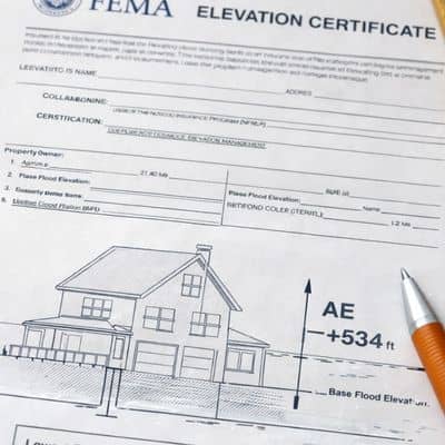
An elevation certificate is an official document prepared by a licensed land surveyor or engineer. It shows the precise height of your home compared to the Base Flood Elevation (BFE), which represents the predicted height floodwaters could reach during a major storm.
Instead of relying on a general map, insurance companies use this document to calculate real risk.
For example, if your lowest finished floor sits above the BFE, your flood risk drops significantly. As a result, your premium may decrease. In stronger cases, FEMA may determine that your structure does not belong in the high-risk zone at all.
In other words, the elevation certificate replaces guesswork with measurements.
Why This Matters So Much in Los Angeles Right Now
Southern California has seen stronger rain patterns in recent years. Flash flooding has affected parts of the Valley, low-lying areas, and neighborhoods near flood control channels. Because of these events, lenders and insurers have become stricter.
At the same time, many FEMA flood maps remain based on older topographic data. Development, grading changes, and infrastructure improvements may have altered actual elevations since the maps were created.
So while your property appears inside a flood zone on paper, it may sit safely above predicted flood levels.
That difference can mean thousands of dollars over time.
How Homeowners Use an Elevation Certificate to Lower Insurance
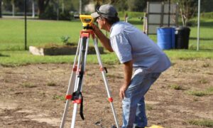
The process starts with verification. First, confirm your flood zone and identify the Base Flood Elevation assigned to your property. Then, hire a licensed land surveyor to measure your home’s elevation accurately.
The surveyor will document details such as the lowest finished floor, the lowest adjacent grade, and the height of key structural components. Once complete, you receive a signed elevation certificate that meets FEMA standards.
Now comes the important part.
You submit the elevation certificate to your flood insurance provider. The insurer must then re-rate your policy using the updated elevation data. If your home sits higher than originally assumed, your premium often drops.
Sometimes the reduction is modest. However, even a few hundred dollars per year adds up quickly. In stronger cases, the difference becomes dramatic.
When an Elevation Certificate Can Remove the Requirement Entirely
In certain situations, the elevation certificate shows that your home sits above the Base Flood Elevation completely. When that happens, you may qualify for a Letter of Map Amendment (LOMA).
A LOMA is FEMA’s official correction stating that your structure does not fall within the high-risk flood zone. Once approved, your lender can no longer require flood insurance.
That step takes patience. Still, many homeowners in Los Angeles have successfully used elevation data to correct outdated flood classifications.
And when flood insurance becomes optional, the savings can be significant.
A Scenario That Happens More Than You Think
Picture a homeowner in the San Fernando Valley near a flood control channel. FEMA maps classify the property in an AE zone. The annual flood insurance premium sits at $2,500.
However, after ordering an elevation certificate, the survey shows the finished floor stands 1.3 feet above the Base Flood Elevation.
The homeowner submits the document. The insurance company recalculates the policy. Eventually, FEMA approves a LOMA.
The result? Flood insurance becomes optional, and the homeowner avoids thousands in future premiums.
That outcome doesn’t happen for everyone, but it happens often enough that it’s worth investigating.
When an Elevation Certificate Won’t Lower Your Premium
Let’s stay realistic.
If your lowest floor sits below the Base Flood Elevation, your premium may not drop. In fact, the document may confirm higher risk. Even then, you gain clarity. You can explore mitigation options like elevating utilities or improving drainage.
Knowledge still protects you.
The key point remains this: you won’t know until you measure.
Who Should Seriously Consider Getting One
If your lender recently required flood insurance, or if your premium increased unexpectedly, you should pause before simply renewing. Likewise, if you plan to refinance or sell your home, flood insurance costs can impact buyer decisions.
An elevation certificate gives you leverage. It gives you data. Most importantly, it gives you the chance to challenge assumptions.
Because flood zones rely on mapping. Insurance relies on numbers. And in Los Angeles, a difference of a few inches can change everything.
The Bottom Line
Flood insurance feels mandatory when you first hear the news. However, in some cases, it doesn’t have to stay that way.
An elevation certificate offers proof of your home’s true elevation. It allows insurance companies to rate your property based on facts instead of generalized maps. For some homeowners, that means lower premiums. For others, it means removing the requirement entirely.
Before paying another year of high flood insurance in Los Angeles, find out where your property actually stands.
Sometimes the solution isn’t moving out of a flood zone.
Sometimes it’s proving you were never truly in one.