How to Find Someone to Survey Your Property Boundary Correctly

There are different reasons why somebody would need boundary surveying in their property. Often, this type of surveying is done if the owner of the property wants to legally place an item on the property such as a new structure or a fence.

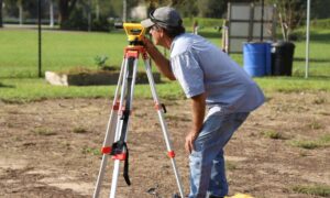
A Licensed Land Surveyor

When hiring a land surveyor, you have to make sure that he is duly licensed by your state. A “licensed” land surveyor means he was able to complete his studies, passed all exams and is certified to perform specific types of land surveys.

Hiring a licensed land surveyor is especially important if there is a dispute over a certain area of a property as the court would be asking for the current boundary survey result as well as testimony from a licensed land surveyor. With this being said, you also have to make sure that the surveyor you’re going to hire can also stand as an expert witness in court.

Looking for a Licensed Land Surveyor

If your property has been surveyed before, it would be easier for you to contact that land surveyor again. This is the best option for several reasons; he already has all information about your property, making it easier for him to perform a new type of survey.

You can typically find your land surveyor’s information on the survey result given to you (if you’ve bought the property from somebody, for instance) or the result given to you by the surveyor himself.

If you don’t have the survey drawing, you can also check the markers put in place by the surveyor during the last survey done on your property. These markers, which looks like iron pegs or pipes, should have the surveyor’s license number/ name on it. You can use this information to find the surveyor online.

If you can’t find the surveyor who worked on your property before, or if the property has never been surveyed, you should easily find a land surveyor in your area (for a land surveyor in the Los Angeles area, click here).

Important Points to Remember when Hiring an ALTA Surveyor

  • As mentioned, make sure that he or she is a licensed land surveyor.
  • He or she should have experience in performing alta boundary surveys. If you’re going to pay somebody, you’d rather have someone who has done it before, right?
  • Look for someone easy to talk to. Communication is very important when hiring a land surveyor. You see, surveying is more of an art than a science – this is why land surveying results vary. It’s important that your surveyor understand why you’re having the survey, what you’re going to use the results for and how soon you’ll be needing the results.

More Posts

An ALTA title survey being reviewed alongside site plans to confirm property boundaries and easements during permit review
alta survey
Surveyor

How an ALTA Title Survey Prevents Costly Permit Rejections

If you plan to build, remodel, or redevelop property, paperwork can stop you before work even starts. Many projects stall during plan check, not because of bad design, but because of missing or unclear land data. An alta title survey helps fix that problem early. When done right, it gives

Read More »
Homebuyers signing paperwork with an agent during a loan closing survey review
alta survey
Surveyor

Loan Closing Survey: What Your Lender Won’t Tell You

If you’re buying a home or refinancing the one you already have, your lender might suddenly say, “We need a loan closing survey.” You hear that and think, Okay… what does that even mean? Then the clock starts ticking. Escrow wants dates. Your rate lock has a deadline. Meanwhile, nobody

Read More »
A surveyor using a tripod and total station to perform a construction survey on a building site
land surveying
Surveyor

Why Skipping a Construction Survey Can Cost Thousands

Los Angeles is known for fast growth, busy job sites, and constant building activity. But right now, something different is happening. A new forecast shows that many developers across California are delaying or slowing down their projects. Because of higher costs, supply chain issues, and market uncertainty, more than one-third

Read More »
Aerial surveying view showing large land parcels and terrain patterns from above
land surveying
Surveyor

The Future of Land Records Starts With Aerial Surveying

Land records shape everything in a city. They show who owns what, where people can build, and how much a property is worth. They also affect how fast a project gets approved. Today, many places still use old paper maps and outdated drawings. Because of this, mistakes happen. Lines move.

Read More »
Aerial view of hillside homes where elevation surveys help show how changing flood zones and land movement affect each property
flood damage
Surveyor

Do New Flood Maps Mean You Need Elevation Surveys Now?

Los Angeles homeowners are paying close attention to elevation surveys right now, and for good reason. New local flood-zone updates are rolling out, and many people are finding out their home may sit closer to risk than they once thought. With recent storms, hillside shifts, and fresh reports about land

Read More »
Digital HUD view showing how a robotaxi scans the road ahead using lidar mapping to understand street details in real time
flood damage
Surveyor

Why Is Lidar Mapping Becoming Key for Robotaxis?

Los Angeles changes fast. New bike lanes appear overnight, construction zones shift every week, and traffic never stays the same for long. While most people only notice these changes when they’re stuck in traffic, something else is happening quietly on the streets every single day. Robotaxis are driving around the

Read More »