Land records shape everything in a city. They show who owns what, where people can build, and how much a property is worth. They also affect how fast a project gets approved. Today, many places still use old paper maps and outdated drawings. Because of this, mistakes happen. Lines move. Neighbors argue. Projects slow down. That’s why more countries now use aerial surveying to update their land records. A major government in India recently announced a plan to map over 130,000 square kilometers using sharp satellite images. This news caught attention around the world, including here in Los Angeles.
Even though the story came from overseas, the message applies here too. There is a push to replace old land documents with accurate digital maps. Cities want better data so they can make quicker decisions, reduce fights over boundaries, and support new development. Since Los Angeles keeps growing, this shift matters a lot. Aerial surveying gives surveyors, homeowners, and developers a clearer view of the land. It brings accuracy that old records cannot offer.
Before we talk about how Los Angeles should prepare, it helps to look at what happened in India and why it signals a major change in land-record systems.
The News That Started the Push for Modern Records
In Tamil Nadu, a state in India, the government asked companies to provide high-resolution satellite images at 30-centimeter clarity. These images are sharp enough to show small structures, boundary changes, and shifts in the land. The goal is simple: update land records and fix long-standing issues with property lines and encroachments.
This story went viral in the surveying world because it shows how fast governments now move toward digital land systems. Instead of sticking with old maps, they want reliable geospatial data that supports modern growth. Since California faces similar issues—like tight space, hillside building, and rapid development—Los Angeles should notice this trend.
Why Aerial Surveying Helps Create Modern Land Records

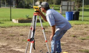
Aerial surveying uses drones, planes, or satellites to capture images and surface data from above. When surveyors mix these images with ground measurements, they get a full picture of a property.
This approach fixes many problems caused by old records. Paper plats often miss details like unpermitted add-ons, fences pushed too far, backyard buildings, or ground changes after storms. When you rely only on old drawings, small mistakes turn into big headaches.
Aerial surveying shows the land as it looks today. It captures building shapes, road edges, slopes, drainage patterns, and even tree cover. Because aerial data covers large areas at once, it also shows how lots connect to one another. That level of detail helps when cities update zoning rules, add housing, or plan new construction in tight areas.
Aerial surveying also works well with GIS mapping, which many cities use to track land use, utilities, and property lines. When land records use GIS, everything becomes smoother. Title reviews go faster. Construction approvals take less time. Boundary issues become easier to solve because the maps reflect the real world.
Why This Trend Matters to Los Angeles
Los Angeles has old homes, new developments, dense areas, and hillside properties. Many land records are decades old. Some were drawn long before GPS existed. Because the city changes often, these old documents do not always match what is on the ground.
Developers deal with slow permits, complex rules, and tight deadlines. Homeowners face boundary questions when they add an ADU or renovate. Surveyors spend extra time checking whether old data is correct. These delays cost money.
Aerial surveying gives a better way to confirm what is true on the ground. It offers clear maps that surveyors, owners, builders, and city planners can all trust. Since L.A. continues to push for more housing and smarter land use, accurate data matters more than ever.
The global shift toward modern land systems suggests the U.S. will follow. When that happens, cities with outdated records will need to catch up fast. Los Angeles can stay ahead by using aerial surveying now rather than waiting for a statewide change.
What Property Owners and Developers Gain
Modern, aerial-updated land records help everyone.
Property owners deal with fewer boundary surprises because aerial maps reveal fences, sheds, patios, and yard changes. Projects move faster because plan reviewers can see up-to-date details. Hillside work becomes safer because aerial surveying captures slopes and terrain changes that affect drainage and grading.
Buyers and sellers understand property values better when records match the real world. And if a boundary problem reaches court, aerial images offer strong visual proof.
With land prices rising and space limited, these benefits matter even more in Los Angeles.
How Surveying Firms Can Prepare for the Shift
Surveying companies can stay ahead by taking a few smart steps.
They can offer aerial surveying as a standard option for clients who want fast, accurate data. When surveyors include aerial images with ground measurements, they give clients a complete view of their property.
They can invest in GIS and stronger data tools. Modern land systems rely on GIS layers, and surveyors who use these tools will serve more clients and fit better into future city rules.
Teams can train in drone mapping, LiDAR, and other remote-sensing tools. These skills help firms stay strong as the industry changes. At the same time, surveyors should help clients understand these tools. Many people do not know how much aerial surveying can protect them from risk and delays.
Finally, firms should prepare for possible California-wide modernization projects. Once the state pushes for updated land records, firms with aerial tools already in place will lead the market.
The Bottom Line
Aerial surveying is becoming the new standard in land-record modernization. The Tamil Nadu project shows the direction the world is heading. As more cities upgrade their systems, accuracy and speed will matter more than ever.
Los Angeles has the chance to move early, reduce delays, and support smarter development. Surveyors, property owners, and developers who understand this shift will stay ahead. Those who ignore it may fall behind as expectations rise.
If L.A. wants clearer boundaries, quicker approvals, and better planning, an aerial survey is the tool that can deliver those results. It brings the accuracy the city needs—before the rest of the world requires it.