Rebuilding is moving quickly across Los Angeles right now. Many property owners are ready to start over, fix damage, or build something new. At the same time, the city is trying to speed up approvals, so it feels like everything should be moving faster. But that’s not what’s happening for many projects. Instead of getting stuck at permits, things are slowing down much earlier. Some projects don’t even make it to the design stage on time. So what’s causing the delay? In many cases, it comes down to something simple that gets missed starting with a land survey. When that step gets pushed back, everything else has to wait, and the project can’t move forward the way people expect.
Rebuilding Is Moving Fast, But Projects Still Stall Early
Many property owners want to move quickly. After all, the sooner a project starts, the sooner it finishes. Because of this, people often rush to hire an architect or contractor first.
At first, this feels like the right move. You want plans. You want progress. You want to see something happen.
However, the design process cannot begin without clear and accurate site information. Architects and engineers need to understand the land before they can draw anything. Without that, they are missing key details.
As a result, the project pauses. Even though the goal is to move fast, it ends up slowing down right at the start.
Why a Land Survey Becomes the First Real Step

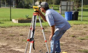
A land survey gives you a clear picture of your property as it stands today. It shows where the boundaries are, what’s on the land, and how the site actually looks right now.
That might sound simple, but it matters more than most people expect. Even when a property looks the same, small changes can happen over time. The ground can shift, debris can change the surface, and cleanup work can quietly reshape parts of the lot.
Because of that, design teams can’t just rely on old information. They need to see what’s really there before they begin.
That’s why they often ask for a current land survey of the property before moving forward. Without it, they’re missing key details, and the project ends up waiting before anything can really get started.
The Delay That Happens Before Anyone Expects It
This is where many projects in Los Angeles run into trouble.
A homeowner hires a designer. The designer asks for site information. Then the homeowner realizes there is no updated land survey available.
At that moment, everything stops.
Now, the next step is to find a surveyor, schedule the work, and wait for the results. In a busy market like Los Angeles, that can take time. Meanwhile, the design team cannot proceed.
Because of this, the delay happens before drawings, before permits, and before any real progress. It is an early pause that many people do not plan for.
Why Old Information No Longer Works
Some property owners believe they already have what they need. Maybe they have an older survey or some past records. At first, this seems helpful.
However, land conditions can change over time. Fire damage, cleanup work, and natural shifts in the ground can all affect a property. Even small changes can make a big difference when it comes to design.
Because of this, older information often does not match what is on the ground today. If a project relies on outdated data, problems will show up later.
So instead of saving time, skipping an updated land survey often creates more delays.
Why Los Angeles Makes This More Challenging
Los Angeles has unique conditions that make this issue more noticeable. Many properties sit on slopes or uneven ground. Because of that, small changes in elevation can affect how a structure is designed.
In addition, properties are often close together. Boundaries matter more in these tight spaces. A small error can lead to bigger problems.
At the same time, rebuilding activity is increasing. More people are starting projects, which means surveyors are in higher demand. As demand grows, wait times can grow as well.
Because of all this, timing becomes more important than ever.
Planning Ahead Makes All the Difference
The good news is that this problem is easy to avoid with the right timing.
Starting with a land survey helps set everything in motion. When the survey is ready early, designers can begin without delay. From there, the project flows more smoothly.
It also helps to connect your surveyor and design team early. When they work together, they can move faster and avoid miscommunication.
Instead of reacting to delays, you stay ahead of them.
Why This Step Matters More Than Ever
Rebuilding is gaining momentum. Projects are moving forward, and opportunities are growing. At the same time, expectations are higher.
However, speed at the permit stage does not help if a project cannot reach that stage in the first place.
That is why the land survey plays such an important role today. It is not just another step. It is the starting point that supports everything else.
Without it, even the most planned project can slow down.
Final Thoughts
Rebuilding a property should feel like progress, not frustration. Still, many projects slow down before they even begin. The reason is often simple—missing or outdated site information.
A land survey helps solve that problem early.
So if you are planning to rebuild, take a moment to start with the basics. Get accurate information about your property. Plan ahead. Give your project the best chance to move forward without delays.
In the end, a small step at the beginning can save a lot of time later.