When news broke that San Diego’s Midway Rising project might use new state housing laws to skip local height limits, it got people talking across California. If state law can overrule city zoning, what happens next for Los Angeles builders? For anyone planning a project near a train line, this change could shape how fast — and how tall — new buildings go up. And that’s where an ALTA survey becomes important.
An ALTA survey isn’t just a simple map. It’s the document that keeps every part of a property deal clear — for lenders, title companies, architects, and builders. When the rules change, the survey is the one piece of proof everyone can rely on.
The San Diego Story That’s Reaching Los Angeles
The Midway Rising project in San Diego made headlines for trying to use state housing laws to build higher than the city’s 30-foot limit near the coast. That move tests how much power the state has over local zoning. Developers are watching closely.
If that approach works, L.A. projects near Metro stations could use the same laws to add more height or density without waiting for city approval. That could help speed up housing, but it also squeezes the time for surveying, permitting, and financing. When property lines, easements, and air rights get confusing, the first step to clear things up is a new ALTA survey.
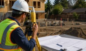
What an ALTA Survey Really Does

An ALTA survey — short for American Land Title Association survey — is the highest standard for property documentation. It combines title research, boundary measurements, and visible site features into one certified map. Unlike a basic boundary or topographic survey, it includes easements, encroachments, access points, zoning notes, and improvements that affect how land can be built or financed.
Lenders and title companies depend on this data before they approve funds or insure a property. It’s like the “truth map” that shows what’s legally and physically on the ground. In a fast-changing policy environment, that truth keeps projects steady.
Imagine a developer wants to add two floors to an apartment building in Koreatown using new state bonus rules. The architect changes the building shape to fit the new design. Without an updated ALTA survey, no one can be sure where the property ends, where setbacks begin, or if the new footprint crosses into an easement. That missing detail can hold up the entire project.
Why New Laws Put More Pressure on Surveys
California’s push for more housing is speeding everything up. Laws like SB 79 and SB 423 aim to cut long reviews and fast-track projects near transit. While that’s great for building more homes, it puts extra pressure on surveyors and design teams to deliver accurate land data faster.
When a project moves from concept to approval in weeks, there’s no room for mistakes. A survey done six months ago might already be outdated. That’s why more developers now order new ALTA surveys early — before their first city meeting, not after.
Having verified boundary, title, and topographic data ready helps them prove compliance and avoid rework later. It also saves money, since every redesign without the right survey means new drawings, more engineer time, and extra city fees.
How It Affects Lenders and Title Companies
When laws blur zoning limits, financial risk grows. Banks and title companies need clear, certified surveys to confirm that a project’s footprint matches the legal lot. If a developer builds taller or denser under new state laws, the ALTA survey protects everyone.
- Lenders use it to confirm their loan is tied to the right property.
- Title companies use it to make sure coverage matches the actual site.
- Developers use it to prevent expensive mistakes like setback violations or encroachments.
Without this document, no one can move forward with full confidence. As zoning rules shift, an up-to-date ALTA survey keeps everyone on the same page.
The Real Impact on Los Angeles Projects
Los Angeles has hundreds of sites near Metro lines — many are parking lots or single-story shops ready for reuse. If state housing laws allow more height, we’ll see more mid-rise buildings and mixed-use projects in those areas.
That means tight spaces, shared access drives, and more overlapping easements — all needing clear maps. An ALTA survey does more than show property lines. It also shows how a property connects with its neighbors. It’s the base for every design step: where to place the building, how to route utilities, and how to stay within the law.
Unlike hillside rebuilds, where slope and erosion matter, these urban projects focus on entitlement accuracy — proving every inch of the design matches city and state rules. Surveyors now work closely with planners and attorneys to make sure the data behind every permit is exact.
A Look at a Typical L.A. Infill Site
Picture a 15-acre site along the Metro E Line. A developer wants to turn a strip mall into a six-story apartment complex using a state housing bonus. They need to confirm the exact property limits, find all easements, and verify street access.
Before design starts, the survey team performs an ALTA survey tied to the latest title records. They mark where new utility lines will go, where corners must meet setbacks, and where old records don’t match what’s actually there. That single map becomes the base for financing, permits, and construction staking.
Later, if the city questions whether the project crosses a line or breaks a setback, the developer has proof it doesn’t. That’s the strength of an ALTA survey — it keeps the project legal, confident, and on track.
Why Timing Matters
Many builders wait too long to order a survey, thinking it’s just for closing. But in today’s climate, waiting can cause delays. The moment your project uses a state housing rule or zoning change, your survey data must match your current plans.
Getting the survey done early avoids headaches. It lets architects design with real numbers, helps lenders approve loans faster, and gives title companies fewer reasons to delay. The sooner the ALTA survey is complete, the smoother the approval path becomes.
Final Thoughts
The Midway Rising case isn’t only about one city’s skyline. It’s a glimpse of how state housing policies are reshaping development across California. For Los Angeles, that means faster projects, taller buildings — and more need for precision.
An ALTA survey doesn’t just draw property lines; it builds certainty. When height limits fall and new rules rise, that certainty is what keeps every project safe, funded, and compliant.