Los Angeles has always moved fast. Now, the skies above the city move fast too. In 2026, public agencies across Los Angeles continue to expand their drone programs. Police teams, emergency crews, and city workers now use drones every day. Because of this, more drones fly across the city than ever before. At first, this may not seem related to construction or land development. However, it directly affects drone land surveying. When more public drones share the sky, private survey teams must plan more carefully. Developers, property owners, and engineers need to understand how these changes affect project schedules and planning.
Los Angeles Has More Drones in the Air
Over the past year, Los Angeles has increased its use of drones for public safety and city support. New docking stations allow emergency drones to launch quickly. As a result, drones now operate in more neighborhoods.
Because of this growth, the sky no longer feels open and empty. Instead, it works like a shared road. The more traffic you have, the more planning you need.
At the same time, private companies also use drones. Construction firms, engineers, and surveyors rely on them to gather accurate site data. So now, public and private drones share the same airspace.
For drone land surveying teams, this means stronger coordination and better planning.
Airspace Rules Matter More Than Ever
Before flying a drone, professionals must check airspace rules. In Los Angeles, this step has become even more important.
Large parts of the city fall under controlled airspace near LAX, Burbank Airport, and Long Beach Airport. Because of that, survey teams often need FAA approval before flying. Systems like LAANC help speed up this process, but pilots must still follow strict rules.
Also, temporary flight restrictions can appear at any time. Large events, security concerns, or emergency operations can limit flights. Therefore, experienced drone land surveying firms always check for restrictions before setting a flight date.
For property owners, this means one thing: work with professionals who understand the rules. Good planning prevents delays.
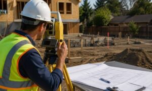
How This Can Affect Project Schedules
Most developers order surveys early in a project. Accurate maps help engineers design buildings, parking lots, and utilities. However, when airspace becomes busier, scheduling takes more care.
For example, survey teams may choose certain times of day when airspace activity is lower. In some cases, they may adjust flight times to avoid conflicts. While these changes seem small, they help prevent denied flights or costly repeat visits.
In addition, early planning gives survey teams time to secure approvals before construction starts. When teams plan ahead, projects stay on track.
Airspace growth does not stop development. Instead, it rewards smart preparation.
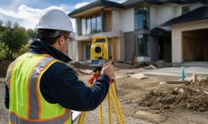
Drone Land Surveying Is Professional Work

Some people still think drones are simple cameras in the sky. That idea does not show the full picture.
Professional drone land surveying involves licensed pilots, survey-grade equipment, and oversight from licensed land surveyors. Teams use advanced systems to improve accuracy. Then, they turn the data into clear maps that engineers can trust.
Because Los Angeles airspace grows busier, professionalism matters even more. Firms must follow federal and local rules. They must carry insurance. They must also protect collected data.
For developers, this reduces risk. Accurate survey data supports permits, design plans, and inspections. It also protects long-term investments.
Growing City, Growing Demand
Los Angeles continues to grow. New housing projects, commercial buildings, and warehouse expansions appear across the city.
In crowded urban areas, traditional ground surveying can take longer. Crews must work around traffic, tight spaces, and busy streets. However, drones collect large amounts of data quickly and safely.
That speed helps engineers design faster. It also helps project managers meet deadlines.
At the same time, city reviewers expect clear and updated digital data. Clean aerial mapping supports smoother reviews. Because of this, drone land surveying has become an important part of modern development.
The Sky Is Now Part of the System
Here is the bigger picture.
Los Angeles now treats drone airspace as part of city infrastructure. Just like roads and utilities need planning, so does the sky.
Public drone programs show long-term city planning. Over time, more rules and coordination systems may develop. Professional drone teams will continue to adjust as needed.
Thankfully, drone land surveying already follows structured processes. Survey teams plan flights, review airspace maps, secure approvals, and document everything carefully.
This strong system helps projects move forward safely.
What Developers and Property Owners Should Do
If you plan a project this year, take these steps.
First, contact a drone land surveying firm early. Early coordination gives teams time to check airspace and secure approvals.
Second, ask about regulatory planning. A professional firm should explain how it handles FAA rules and local limits.
Third, include survey scheduling in your full project timeline. Drone surveys move fast, but approval steps still require planning.
Finally, focus on long-term value. High-quality survey data supports design accuracy and reduces costly mistakes.
When you treat drone land surveying as part of your strategy, your project stays steady from start to finish.
Looking Ahead
Los Angeles will likely continue expanding public drone programs. As technology improves, more drones will fly across the city.
However, this growth does not create barriers. Instead, it raises standards.
Drone land surveying remains one of the fastest and most accurate ways to collect site data. In 2026, success depends on careful planning, strong compliance, and experienced professionals.
The skies above Los Angeles may be busier. Still, with the right team, your project can move forward with confidence and clarity.