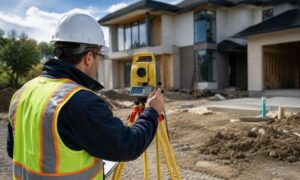
Many people still picture land surveying the same old way. They imagine a surveyor with a tripod, standing in the field all day. That still happens. However, the tools behind modern land surveying have changed very fast. Today, surveyors also use AI-assisted software, LiDAR scanners, and drone mapping to collect and study land data.
These new tools do not replace skilled surveyors. Instead, they give them better data and clearer site views. For property owners, builders, and developers, this means better answers early in the project and fewer surprises later.
Why Land Surveying Is Changing So Fast
Projects now move on tight schedules. Cities grow quickly, permits take time, and design teams want more detail at the start. Because of this, land surveying has added new geospatial tools that speed up both fieldwork and office work.
In the past, crews measured points one at a time. That method still works well for boundary lines and control points. However, large sites and rough terrain need wider coverage. New tools can now scan or photograph whole areas and turn them into detailed surface maps.
At the same time, AI-based software helps sort and clean the data. Instead of spending days organizing raw points, survey teams can review clean models much sooner. As a result, projects move faster while accuracy still stays strong.
What AI Really Does in Land Surveying
AI in land surveying is not a robot making final decisions. It works more like a fast helper. It reviews large data sets and organizes what the field team collected.
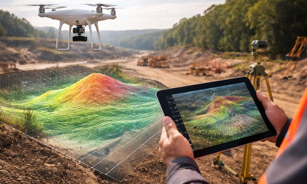
For example, after a LiDAR scan or drone flight, the software can tell the difference between ground, trees, and buildings. It can build terrain surfaces and spot odd data points. It can also show where more data may be needed.
Because of this, surveyors spend less time doing repeat computer tasks. They spend more time checking results and making sure the data makes sense. Clients benefit because they receive usable maps faster, with expert review still in place.
So AI speeds up the process, but a licensed surveyor still approves the work.
How LiDAR Improves Topographic Work
LiDAR now plays a big role in land surveying. It sends many small laser pulses to the ground and measures how they return. From that timing, software builds a very detailed elevation model.
This helps most on land with trees or uneven ground. Normal field shots can miss hidden dips or slope breaks under thick cover. LiDAR often captures enough detail to show the real ground shape.
Because of that, topographic surveys become more complete. Engineers can study slopes, drainage paths, and grade limits earlier. Therefore, design teams can adjust plans before they spend too much time or money.
For clients, this leads to better early planning and fewer redesigns.
Why Drone Mapping Became So Popular
Drone mapping also changed how land surveying teams study large parcels. A drone can take hundreds of photos in one short flight. Processing software then turns those photos into scaled maps and 3D surfaces.
This works well for big sites and active construction areas. Crews do not need to walk every corner just to understand the layout. Instead, they capture the whole site from above and then check key spots on the ground.
Builders and developers like this because it saves time. Updated site maps help teams compare design grades with real ground levels. That view helps prevent mistakes during earthwork.
Even so, trained surveyors still plan the flights, set control points, and check accuracy. The drone gathers data, but the surveyor confirms it.
What Clients Notice Most About Modern Land Surveying
Most clients do not focus on the tools. They focus on speed, clarity, and trust. Modern land surveying tools affect all three.
Projects often start with better site knowledge. Surface models and aerial views arrive earlier in planning. Because of that, design teams can test ideas sooner.
Large properties also become easier to understand. Wide data capture reduces the chance of missing key features. That early insight lowers project risk.
At the same time, faster processing helps meet tight buying and loan timelines. When deadlines feel close, every saved day helps.
Why Licensed Surveyors Still Lead the Process
Even with advanced tools, licensed experts still lead land surveying work. Technology improves measurement, but it does not replace legal responsibility.
Only a licensed surveyor can certify boundary lines and official survey documents. Only a licensed surveyor can stand behind the final results. That role matters even more when data sets grow larger.
Think of modern tools as power tools. They help the expert work faster and see more. However, the expert still makes the final call.
For clients, this mix of technology and professional judgment creates strong, reliable surveys.
The Future of Land Surveying Looks Smarter and Faster
Land surveying continues to improve as new tools arrive. AI-assisted software, LiDAR, and drones now support faster and clearer workflows. Over time, these systems will become even better connected.
Still, the main goal stays the same: measure land correctly and explain it clearly. Good surveys always depend on field control, training, and careful review.
The big change today is visibility. Surveyors can now see sites in more detail and in less time. Better visibility leads to better decisions.
So when you order land surveying today, you receive more than measurements. You get modern geospatial technology guided by licensed expertise — and that gives your project a stronger start.