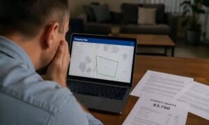
You pull up your property online. The lines look clean. The lot shape makes sense. It feels simple. Then you call for a survey and get a quote that feels way higher than expected. That’s usually the point where people pause and start digging into survey costs for properties, trying to figure out what they missed. Most property owners assume the map tells the full story. It doesn’t. What you see online is only a rough guide. A real survey proves what exists on the ground, and that difference is where property survey cost starts to change.
What Online Parcel Maps Show—and What They Leave Out
Tools like ZIMAS help you look up zoning and parcel details. They are useful when you want a quick view of your lot.
Still, those lines are not measured on your land.
They come from past records. Some are old. Some were copied from earlier maps. Others may not reflect changes made over time. Because of that, the map can look accurate even when small details are off.
That matters more than people expect. A few inches or a slight angle difference can affect where a structure sits. So while the screen shows a neat outline, the ground may tell a different story.
Why Property Survey Cost Increases Once Work Begins
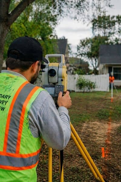
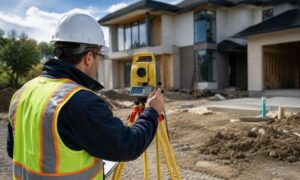
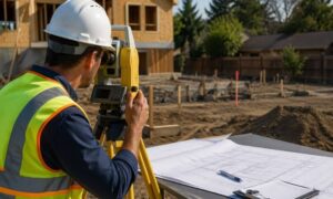
The moment a surveyor steps onto the property, the job shifts from reading a map to proving real boundaries. That’s usually when it starts to click why the price isn’t always as simple as it first seemed, and you begin to see what actually affects property survey cost.
Surveyors start by looking for physical markers that define the edges of the property. Some are easy to spot. Others are buried, damaged, or missing. When that happens, they have to spend more time measuring and confirming where those points should be.
At the same time, records don’t always match what exists today. In many parts of Los Angeles, older legal descriptions still point to features that are no longer there. So the surveyor has to compare documents, sort through differences, and figure out what still applies.
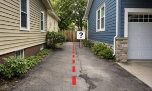
Then there are visible features like fences, walls, and driveways. People often assume these follow property lines. They don’t always. When something sits close to or crosses a boundary, it has to be measured and documented carefully.
Lot shape adds another layer. A simple rectangle is quick to handle. A curved or irregular lot takes more effort. Slopes, tight spaces, and limited access can slow things down too. Even when the map looks straightforward, the actual site can tell a very different story.
Why This Happens So Often in Los Angeles
Los Angeles has a mix of older neighborhoods and newer developments. That mix creates small gaps between what is recorded and what exists today.
Many properties have changed over time. Additions, repairs, and small shifts in structures can affect how a lot is used. At the same time, nearby properties may have their own changes, which can impact shared boundaries.
Because of this, two homes on the same street can have very different survey needs. One may be simple. The other may require deeper checking. That difference shows up in property survey cost.
When Online Tools Help—and When They Don’t
Online maps still have value. They help you understand zoning rules and give a rough idea of lot size and shape. That makes them useful early in the process.
However, they stop short of giving legal certainty.
You need a real survey when you want exact boundaries, when you plan to build, or when you need to avoid problems later. At that point, relying only on a map can lead to mistakes.
A survey replaces guesswork with confirmed information.
What You’re Really Paying For
Property survey cost reflects the work needed to remove doubt.
You are not just paying for measurements. You are paying for someone to verify records, confirm boundaries on-site, and make sure everything lines up correctly.
That process protects you. It helps prevent issues that can delay projects or lead to costly fixes later. Without it, small errors can turn into bigger problems once work begins.
How to Approach a Survey the Right Way
A little preparation can make a difference.
Start by knowing what you need the survey for. A clear purpose helps the surveyor focus on the right level of detail. Sharing any existing documents also helps speed up the process.
Timing matters as well. When you plan ahead, the work can move at a steady pace. When you rush, costs often increase.
Even then, it helps to stay realistic. A property that looks simple online may still require careful checking on-site.
Understanding Property Survey Cost Before You Decide
Online maps make property lines look easy. Real land is not always that simple.
Property survey cost in Los Angeles depends on what it takes to confirm the truth on the ground. That includes checking records, measuring the site, and resolving differences between the two.
Once you understand that, the price starts to make more sense. It also helps you avoid surprises before you move forward with any plans.